
VOLUNTEER WITH US

Citizen Observer
See something? Say Something.
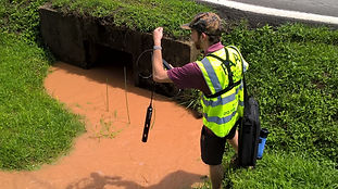
Citizen Observers are the eyes and ears and the front lines of the Pipeline CSI. This is a way that almost anyone can participate in our program. Observe, document, and report incidents of impacts to streams and of noncompliance with construction requirements.
Anyone with two eyes, a camera or a phone, can fill this role!
We recommend using an app like Solocator (pictured left) to take the best photo evidence!
Go above construction to see beyond the treeline. Seeking volunteer pilots and licensed drone pilots to document construction in remote areas.
Local organizers and community leaders act as our points of contact for local areas, in accordance with our goal of working in solidarity with autonomous local coalition members and member groups.
Construction of large pipelines across the Appalachian region unavoidably results in noncompliance with runoff control requirements. Many types of noncompliance that should result in enforcement action by regulatory agencies are readily observable both onsite and through photographic and/or video evidence. The Top-Ten List highlights types of noncompliance that are among the most frequent or significant; report these when you see them!
The slideshow below offers some examples but the best place to learn more is by reading the full Top Ten List Document
The Top-Ten List
-
Failure to install, or delayed installation of, erosion and sediment control (ESC) measures.
-
Deviation from approved ESC and construction plans.
-
Missing, failed, damaged, or improperly installed or maintained silt fences, filter socks, or other perimeter control devices.
-
Missing, failed, damaged, or improperly constructed right-of-way diversions (water bars or slope breakers) and outlet structures.
-
Formation of earthen slips or downslope gullies within or at the perimeter of the construction right-of-way.
-
Sediment deposition off-site or outside of the permitted limits of disturbance.
-
Sediment discharge into streams and wetlands.
-
Failure to stabilize construction areas, bare ground, and stockpiles of spoil or topsoil after active disturbance.
-
Failure to construct and properly maintain construction entrances at public roads.
-
Failure to contain petrochemicals

#1
FAILURE TO INSTALL OR DELAYED INSTALLATION OF EROSION & SEDIMENT CONTROL(ESC) MEASURES
GENERAL GUIDANCE
CSI Central will follow-up on significant citizen reports by dispatching CSI Incident Response Teams to obtain aerial photography, water data, and other information to confirm and investigate reported problems. Information collected by the CSI Response Teams will be posted on the CSI Mapping System, made available to the public, and submitted to the responsible regulatory agencies in cases when noncompliance is confirmed or when it is evident that required control measures are incapable of preventing water resource harm.
The following summarizes some of the major stream impacts, noncompliance issues, or failures of control measures that may be evident to citizen observers.
Corridor and Access Road Observations
When observing the construction corridor, access roads, and other disturbed areas look in particular for a lack of, or failure of, erosion controls, including evidence of concentrated flows, and evidence of sediment moving offsite. Most problems will be evident during or shortly after rain or snow melt.
-
Failed, mismanaged, or missing downgrade perimeter control structures
-
Failed, mismanaged, or missing water diversions
-
Discharge or runoff of sediment-laden water without sediment removal
-
Earth disturbance to edge of stream without erosion controls
-
Presence of erosion gullies
-
Presence of earthen slips, landslides, or washouts
-
Presence of mud tracked on to public roads from construction corridor and other disturbed areas
-
Sediment-laden runoff from access roads and the presence of mud and ruts on road surface
Downstream and Stream Crossing Observations
When observing streams look in particular for indications of erosion and sedimentation, changes in runoff properties, or evidence of petroleum contamination. Many problems will be most evident during or shortly after rain or snowmelt.
-
Sediment plume, muddy water, or other discoloration
-
Sediment deposits on streambed, stream bank, or adjacent areas
-
Stream bank erosion and undercutting and damage to aquatic habitat.
-
Equipment in streams
-
Oily film on water surface or petroleum smell
-
Evidence of spill control or cleanup efforts
CSI VOLUNTEER GUIDANCE DOCUMENTS
We have created these documents, videos, and playbooks to guide your participation in the CSI program and help you defend our region from harm and under-regulated construction. In most cases, the most recent date that a document was updated is written in a corner of the document's first page.
New helpful (and printable!) documents and guides will be posted on this page in the list below.

TOP TEN LIST
Use this guidance to know what kinds of violations are most important to report to the CSI. This list has been well researched.

MAPPING SYSTEM WEBINAR VIDEO
Prefer to watch a video? Press play to hear Dan Shaffer and Ben Cunningham walk you through using the CSI Mapping System.

CSI AVENZA MAPS ANDROID INSTRUCTIONS
Follow the instructions on this page to install Avenza Maps app on your Android device and import the offline maps relevant to you into the app.

LOCAL COORDINATOR PLAYBOOK
Use this playbook as a guide for coordinating neighbors' and local landowners' observations with CSI reporting.

EROSION CONTROL TRAINING VIDEOS
Courtesy of Kirk Bowers & Mountain Valley Watch

CSI AVENZA MAPS iPHONE INSTRUCTIONS
Follow the instructions on this page to install Avenza Maps app on your iOS device and import the offline maps relevant to you into the app.

MAPPING SYSTEM USER GUIDE
This User Guide will help you navigate the CSI Mapping System online.

AERIAL PHOTO REVIEW GUIDEBOOK
Learn how to interpret aerial photos from the Pipeline Air Force to help us file complaints against the pipeline.

CSI AVENZA MAP INDEX
Open this pdf on your device and then click the map sections you want to import into the Avenza Maps app. You can also import via the URL links on the second page of this document.